Distance from the lodge:
5 miles WSW ~11 min drive DG5 4LB

As soon as we heard about the walk to Rough Island, we looked forward to exploring the island. (We’ve previously done a similar walk to Davaar Island off Campbeltown, Kintyre.)

This area of the Solway Coast has such shallow seas that there are vast mudflats when the tide is out.
Rough island is about 3 miles / 5km from from Serenity 22 Barend “as the crow flies”.
⚠️ Check when to avoid crossing as the causeway is underwater for 5 (five) hours during high tide.
The island is opposite Rockcliffe beach, but there’s a hard causeway from a beach near Kippford. So, we drove about 10 mins, parked in Kippford and then walked along the sea front and across the causeway.
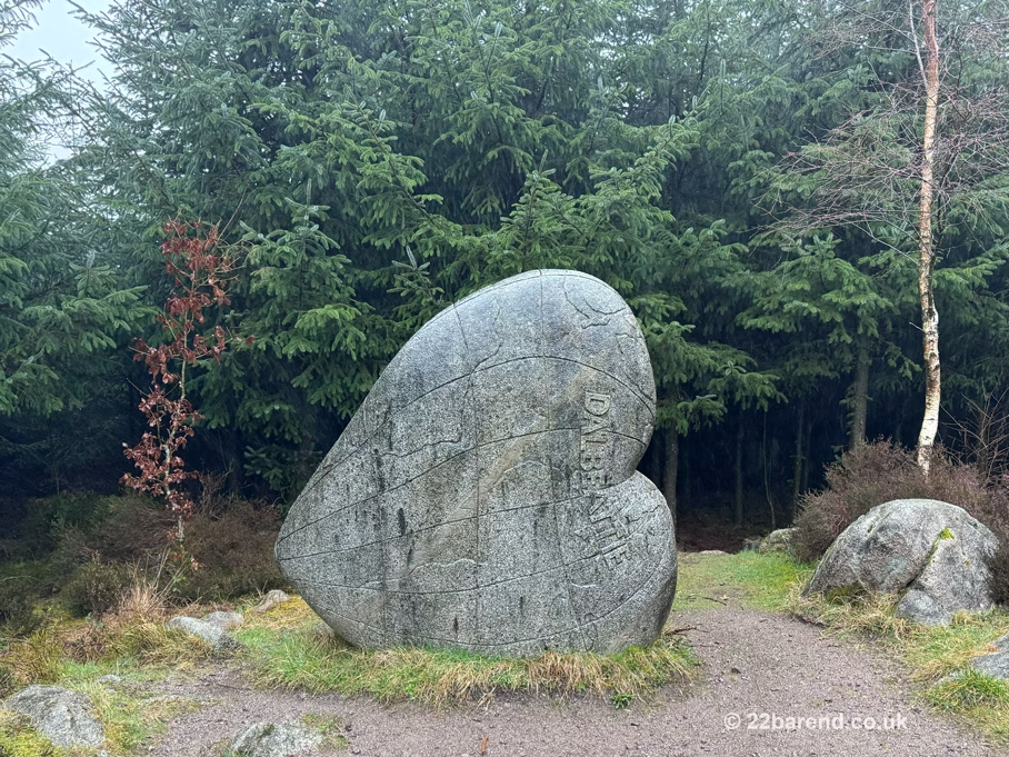
On the beach at Kippford is the Woodland Trust’s UK Tree of the Year 2021 winner.
Quick info for visiting Rough Island:
- Drive from Serenity (22 Barend): 5 miles (~11 min drive)
- Parking: Village Hall (Donation)
- Walking Time: ~2 hours (Return)
- Difficulty: Moderate (Tidal/Uneven)
- Bird Season: Avoid visiting 1st May – 31st July, take care March & April.
- Dogs: Welcome on a lead (and under close control)
- Tide Times: ⚠️ Check Rockcliffe Tide Times (Essential). Causeway is underwater for 5 hours at high tide.
Book your self catering accommodation near Kippford, Rockcliffe and Rough Island: Check Availability
What Time of Year to Walk
Rough Island is a small tidal island in the Rough Firth. Walkers are discouraged during bird nesting season (the busiest time for nesting birds is from 1st March until 31st July). This is to avoid disturbing the nesting oystercatchers and ringed plovers.
So it’s best to walk it between August and February, but also ‘allowable’ with care in March & April. On the day we walked it in December, low tide was around 1pm, so we set off from our car at about 11:45am. This gave us around 2½ hours of the lowest tide to get there and back. This was plenty of time, including a picnic on the island.


The Crossing
There’s hard ground to walk the crossing, so you can (mostly) avoid the softer mud. Wellies are strongly recommended, but if you haven’t brought any with you, you should be OK with walking boots, but we’d recommend a change of footwear for the drive home!
When we got to the island we couldn’t immediately see a path to the top, so we headed round to the right. We found out later that this was the more sheltered side on the day we visited. We stopped on the beach and enjoyed a picnic looking out across the estuary.


After lunch we walked around to the other side of the island, where it was a bit windier and from there you can see the beach at Rockcliffe. With your wellies on, you can probably nip across the sand from there.
Path to the Top
Just before heading back, we had another look for a path to the top of the island. It’s reasonably easy to see once you know it’s there!


It’s a short walk up the path to the highest point on the island, through the bracken.
At the top there’s a cairn of rocks that other walkers have collected. There’s also plenty of space to have a picnic up there instead of on the beach if you prefer.


After that brief excursion we headed back across the causeway and sand to Kippford.
Our walk, including going around the island, was just over 4 miles (around 7km) and took just over 2 hours in total.
Exploring the estuary and climbing to the summit of Rough Island is a great way to spend 2 or 3 hours. If you’re looking for a comfortable, well-equipped base for relaxing in Dumfries & Galloway, we’d love to host you at Serenity. You can check our current availability here.
Book your self catering accommodation near Kippford, Rockcliffe and Rough Island: Check Availability
For more walks and hikes near Kippford and Rockcliffe, see our Walking & Hiking post or the Walking and Hiking tags. We’ve seen another ’causeway’ island we will try walking to this year and will report on that when we have, stay tuned!
Planning Essentials
Address, Links & Reviews
Trail Map: Our Kippford to Rough Island Route (AllTrails)
Scottish Places website info on Rough Island
Rough Island on Google Maps | Rough Island on What3Words ///yards.dealings.regulator
Planning Your Trip
Distance: 5 miles WSW ~11 min drive DG5 4LB (to Village Hall Car Park)
The car park is free, but a donation toward its upkeep is appreciated. Just push your donation through the slot on the door of the Village Hall.
Navigation: Google Maps | Waze | ///viewers.giving.supposes
Our Tips
- Footwear: Walking boots may be OK, but wellies recommended.
- Birds: Please avoid the island from 1st March to 31st July to protect ground-nesting birds.
- Dogs: Welcome but please keep them under close control, especially during the bird nesting season and in areas where livestock are grazing. – NTS
- Toilets: There are toilets at the Kippford Village Hall Car Park
- Refreshments: The Mariner and The Anchor (Apr 26: re-opening soon) pubs and licensed cafe The Ark in Kippford are great for a post-walk meal or drink.
- Tides: ⚠️ Check Rockcliffe Tide Times (Essential). Causeway is underwater for 5 hours at high tide.